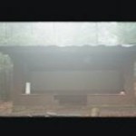
Coosa Bald (4,271 feet) is one of the ten highest peaks in Georgia and it is accessible via the Duncan Ridge Trail which starts near Vogel State Park. The summit hardly qualifies as a bald these days and Mother Nature has mostly taken back this once open area. So if you want some views - go before the leaves bud on the trees, but you'll likely have the place to yourself. Bonus: Here we are at the summit enjoying the views to the South and the sunset to the West. … [Read more...]
A Spring Hike To Coosa Bald (Via The Duncan Ridge Trail)
April 22, 2013 By Leave a Comment

Sixteen years ago, The Ox and I did a winter ascent of Coosa Bald (4,271 feet) via a spur off the Coosa Backcountry Trail. I remembered a few campsites scattered near the summit and decided to return via a much shorter route this time. Coosa Bald is located near (and approachable from) Vogel State Park, and we stopped at Neel's Gap a few miles South of the park. The store was busy on this cool and clear weekend, and The Weasel snapped this photo of hiking boots hanging in the trees … [Read more...]
Appalachian Trail Virus Runs Rampant In North Carolina
April 16, 2013 By Leave a Comment
There is a virus running rampant in shelters on the Appalachian Trail in western North Carolina. Not the best place to come down with a stomach bug!!! No Business Knob ShelterPress release from the U.S. Forest Service. Spokesman Stevin Westcott said he is unsure how long it will be before the virus subsides. HOT SPRINGS — Hikers may want to avoid sections of the Appalachian Trail near Hot Springs, N.C., especially the stretch running north to the Tennessee border. A number of … [Read more...]
Episode 12: Trail Work
February 10, 2013 By Leave a Comment

In Episode 12, I speak with Amy (aka Mrs. Weasel) in a Banner Elk interview about her experiences on the trail. These include hiking, backpacking, and volunteering along the Appalachian, Benton MacKaye, and Pine Mountain Trails in Georgia, North Carolina, and Virginia. In the podcast, Amy talks about doing trail maintenance as part of the Konnarock and Georgia Appalachian Trail crews in the Southeast, her quest to finish the Georgia section of the Appalachian Trail, and what it's like to … [Read more...]
THE KLONDIKE 2013 (AKA THE SEARCH FOR LONG BRANCH SHELTER)
February 9, 2013 By Leave a Comment
This is a video slide show of our hike to Long Branch Shelter from Standing Indian Campground. It was sunny when we left Atlanta and the forecast was for temperatures in the 50's in nearby Franklin, N.C. Yet as we drive the 2 1/2 hours north to the Appalachian Trail, there is a line of clouds and a cold front moving in from the Northwest. Mobile checks at the Weather Channel has the forecast in constant flux -- and deteriorating quickly. By morning, there would be 8 1/2 inches of snow … [Read more...]
When The Weatherman Blows The Forecast (aka Our Epic Venture To Long Branch Shelter)
February 7, 2013 By Leave a Comment
It is sunny when we leave Atlanta and the forecast is for temperatures in the 50's in nearby Franklin, N.C. But as we drive the 2 1/2 hours north to the Appalachian Trail we spot a line of clouds and a cold front pushing in from the Northwest. Mobile checks at the Weather Channel has the forecast in constant flux - and deteriorating quickly. The light rain projected to hit in the late afternoon arrives as snow and a winter advisory is issued for North Georgia and Western N.C. But we … [Read more...]
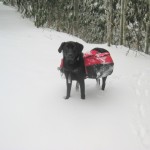
50 Degrees & Sunny?
February 5, 2013 By Leave a Comment
Well ... the weather forecaster blew this one. Here we are on Day 2 and it's still snowing. When we left Atlanta, the forecast was for temps in the 50's in nearby Franklin, N.C. But on the Appalachian Trail (and at 4000+ feet) .... it was a bit cooler!! I wonder if the Boyz will make it out of Standing Indian Campground with two-wheel drive?? … [Read more...]
