This content is password-protected. To view it, please enter the password below. Password: … [Read more...]
Protected: APPALACHIAN TRAIL, TRAY GAP TRIP REPORT – APRIL 18, 2014
April 30, 2014 By Leave a Comment
And the monsoons came. A tale from Good Friday…
April 30, 2014 By Leave a Comment
The kids were out of school for Good Friday recently, so we took them backpacking on the Appalachian Trail near Tray Mountain. Here they are at Tray Gap about a mile from the summit. Even the dog was having a great time at Tray Gap and went straight for a mega muddle puddle at the cross-roads. Three 4x4 Jeeps did the same and entertained the kids before we hit the Trail. All got a good smattering of mud as you can see below... Uh, I gotta sleep with that? We considered … [Read more...]
Spring Has Sprung, Time For A Hike On The Benton MacKaye …
March 21, 2014 By Leave a Comment
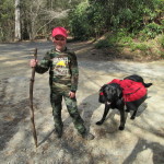
After a unseasonably cool winter, the weather finally broke and we decided to take the kids out for an overnight hike. We did this one on a Friday night to avoid conflicts with spring sports and with spring break. Here we are at the parking area at Three Forks on the Appalachian Trail. The dog is more excited than anyone and is hauling his own food, water, sleeping bag and sleeping pad. All in - the dog's pack weighs about 8 lbs - nearly the same weight as my empty … [Read more...]
Long Creek Falls, Appalachian Trail, Georgia
March 19, 2014 By Leave a Comment
Taking a break at Long Creek Falls in North Georgia on the Appalachian Trail. … [Read more...]
Full Moon Fever
March 19, 2014 By Leave a Comment
Full moon tonight - and there's rumors of Huey's landing in the field with elite Army Rangers nearby. Bet the kids will love that! … [Read more...]
Protected: Wood Collection 101
March 19, 2014 By Leave a Comment
This content is password-protected. To view it, please enter the password below. Password: … [Read more...]
Bill Irwin, First Blind Hiker To Hike The Appalachian Trail, Passes Over The Weekend
March 5, 2014 By Leave a Comment

I read Bill Irwin's book during my 1994 thru-hike - very inspiring. He was the first blind hiker to hike the entire Appalachian Trail and did it with the assistance of his dog Orient. Sad to hear that he has passed over the weekend: "Bill Irwin, who in 1990 became the first and only blind person to hike the entire length of the Appalachian Trail without human assistance or companionship, died Saturday morning." A video story on You Tube... … [Read more...]


