Vickery Creek (via South Atlanta Road)
National Park Service
Chattahoochee National Recreation Area
1978 Island Ford Parkway
Atlanta, GA 30350
Vickery Creek Falls is one of Roswell’s most-visited and most-photographed locations. Created as Vickery Creek Dam to help power the Roswell Mill, this now-famous waterfall is surrounded by hiking trails and years of history. Find Vickery Creek Falls at Old Mill Park. “Vickery Creek is named after a Cherokee woman named Sharlot Vickery who lived in present-day Roswell and owned much of the land around the creek. The creek was originally called Cedar Creek; however, the name was changed to Vickery some time after the arrival of Roswell King and family in 1834.” The creek also became known as Big Creek at some point after the American Civil War.
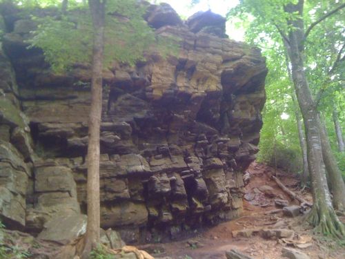
This short hike starts at the parking area for the Allenbrook Historic Mill House off South Atlanta Street in Roswell, GA. The Allenbrook house was built around 1857 and served as the residence and office for the manager of Ivy Woolen Mill. He hoisted a French flag in an effort to save the mills and his home during the Civil War. Union troops destroyed the mills, but left the house. To start this hike, leave the parking area and descend down past the Allenbrook house. A series of steps take you down to a steep cliff where you can descend along the large rock outcropping or you can hang a right and follow an old road down to a series of steps that drop to Vickery Creek. Either way this trail makes a loop with an extension out to the junction of Riverside Road and South Atlanta Street and the stop light an this intersection. The route along the river is pleasant with views out on to the large stream and steep cliffs and caves over a 0.3 mile stretch.
- click for a trip report of this hike to Vickery Creek from Riverside Road: May 12, 2010 (password required)
- click for a trail map of Vickery Creek in the Chattahoochee National Park
- click for a topographical map of the trails at Vickery Creek
- click to see a map of all the parks in the City of Roswell
- click to see another hike to Vickery Creek from the Roswell Mill in November 2014 and January 2022
- click to see a hike to the Roswell Mill from Riverside Road in September 2006
- click to access the trailbook Best Hikes Near Atlanta which has more hikes around the City of Atlanta
- click to access the guidebook Hiking Georgia which has more hikes in Georgia
- click for more Georgia hiking and backpacking books


