MORE INFORMATION:
Appalachian Trail Conference
799 Washington Street
P.O. Box 807
Harpers Ferry, West Virginia 25425
(304) 535-6331
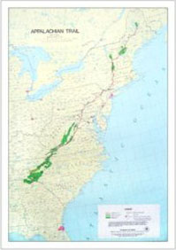
TRAIL STATUS: 100% Built
SOUTHERN TRAILHEAD:
Springer Mountain near Dahlonega, Georgia
NORTHERN TRAILHEAD:
Mt. Katahdin near Millinocket, Maine
BLAZES: White (Standard Blaze)
TYPICAL START DATES:
March 1-April 15, Northbound; July 1, Southbound
TYPICAL DIRECTION: Northbound
DIFFICULTY: Moderate to Difficult
HIGHEST POINT: 6643 feet at Clingman’s DomeGreat Smoky Mountains National Park, North Carolina
LOWEST POINT: 123 feet at the Trailside ZooBear Mountain State Park, New York
STATES HIKED: Georgia, Tennessee, North Carolina, Virginia, West Virginia, Maryland, Pennsylvania, New Jersey, New York, Connecticut, Massachusettes, Vermont, New Hampshire, Maine
HIGHLIGHTS: The Appalachian Trail is a 2164 mile footpath that runs along the Appalachian Mountains from Maine to Georgia. The trail’s northern terminus is in Central Maine in Baxter State Park at Mt. Katahdin. The southern terminus is in North Georgia in the Chattahooche National Forest at Springer Mountain. The Appalachian Trail (or AT as it is often called) crosses 14 states, 8 national forests, 6 units of the national park system, and 60 state park, forest, or game lands. It was the first footpath to be designated by Congress as a National Scenic Trail in 1968. It is now federally protected under the administrative jurisdiction of the U.S. Department of the Interior, but is primarily maintained and managed by the Appalachian Trail Conservancy. The ATC is a private and nonprofit organization which was formed on March 3, 1925 by Benton MacKaye and a small group of private citizens and public leaders. Their mission is to coordinate the numerous federal, state, and local agencies to manage the A.T. and its adjacent lands.


Speak Your Mind