Albert Mountain
Nantahala National Forest
Wayah Ranger District
Franklin, NC 28734
828-524-6441

The Nantahala National Forest is the largest of the four national forests in North Carolina and is the the second wettest region in the country – after the Pacific Northwest. The word “Nantahala” is a Cherokee word meaning “Land of the Noonday Sun.” In some spots, the sun only reaches the floors of the deep gorges in the middle of the day. The National Forest has 531,270 acres with elevation ranging from 5,800 feet at Lone Bald in Jackson County to 1,200 feet in Cherokee County along the Hiwassee River.
Albert Mountain is a prominent peak in the Nantahala National Forest of western North Carolina, near the town of Franklin. The summit sits at an elevation of approximately 5,225 feet, and is one of the last remaining fire towers along the Appalachian Trail. The tower is a 55-foot steel fire structure, constructed in 1951 to replace an older lookout structure in the area. While the cab at the top is typically locked, the stairs remain accessible, offering panoramic views of the surrounding landscape. On clear days, visitors can see the Nantahala Mountains, the Little Tennessee River Valley, and even distant peaks in Georgia and the Great Smoky Mountains. Big Spring Shelter is located a short distance from the mountain and it has numerous tent sites and a spring.
- click for a detailed trip report for this backpacking trip on the Appalachian Trail: April 25, 2002 (password required)
- click for a trip report from this weekend on the Appalachian Trail: April 25, 2002 (password required)
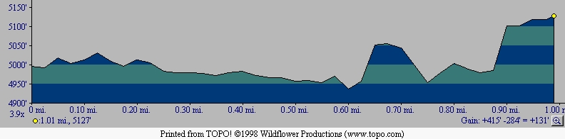
- click for a topo and profile map of this hike to Albert Mountain
- click for a trail map of the Appalachian Trail in Georgia, North Carolina, and Tennessee (password required)
- click for an ATC topo map from GA/NC Border to Wallace Gap Trail Map (password required)
- click for an ATC profile map from the Timber Ridge Trail to Wallace Gap (password required),
- click for the Nantahala and Cullasaja Gorges Trails Illustrated map for this area
- click for another hike at Albert Mountain in November 2001
- click for more information on the Appalachian Trail
- click for Appalachian Trail hiking and backpacking books
- click for the guidebook Appalachian Trail: Georgia-North Carolina which has details on this area
- click for other North Carolina hiking and backpacking books