Wolf Laurel Top (via Tesnatee Gap)
Chattahoochee-Oconee National Forests
1755 Cleveland Highway
Gainesville, GA 30501
770 297-3000
The Chattahoochee National Forest is one of two National Forests in the State of Georgia, and it takes its name from the Chattahoochee River whose headwaters begin in the North Georgia mountains. The River and the area were given the name by the English settlers who heard it from the Indians that once lived here. The Chattahoochee National Forest was created when the Forest Service purchased 31,000 acres in Fannin, Gilmer, Lumpkin and Union Counties from the Gennett family in 1911 for $7.00 per acre. In the beginning, the Chattahoochee was part of the Nantahala and Cherokee National Forests in North Carolina and Tennessee, but eventually the Forest Service made additional land purchases and expanded the Chattahoochee to its current size of nearly 750,000 acres.
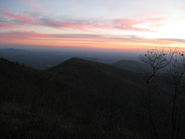
The walk to Wolf Laurel Top is an in-and-out, backtrack hike that is ideal for day hiking, but it can also be done as an overnight backpacking trip. This hike starts along the Richard Russell Scenic Highway and ascends around 700′ feet to a scenic overlook along the trail at Cowrock Mountain. There are spectacular views to the east, south, and west from here and its a great place to take a break after the long climb from the parking area. From here, the Appalachian Trail continues another mile to Wolf Laurel Top. It drops into Baggs Creek Gap where there is a campsite to the left and a blue-blazed side trail down to a piped spring to the right. The final climb to Wolf Laurel Top is about 250 feet where there are outstanding 180 degree views in the summer and 360 degree views in the winter.
- click to see photos from this backpacking trip to Wolf Laurel Top: November 13, 2010
- click for a trip report of this hike on the Appalachian Trail: November 13, 2010 (password required)
- click for a Trails Illustrated map for this hike in the Chattahoochee National Forest
- click for a topographical and profile map to Wolf Laurel Top from Tesnatee Gap (password required)
- click for an ATC trail map from Jarrard Gap to Hog Pen Gap on the Appalachian Trail (password required)
- click for an ATC trail map from Wolf Laurel Top to Chattahoochee Gap (password required)
- click for an ATC profile map from Wolf Laurel Top to Unicoi Gap Profile Map (password required)
- click for a Georgia Appalachian Trail overview map (password required)
- click for a Georgia Appalachian Trail profile map (password required)
- click to view a hike to Wolf Laurel Top via the Byron Herbert Reece trailhead
- click to read an article about The Perch in Backpacker Magazine in the fall of 2022
- click for guidebook info on this hike with a section preview and mile 0.0 to 0.4, plus mile 0.4 to 4.4 (password required)
- click for more information on the Appalachian Trail
- click for Appalachian Trail hiking and backpacking books
- click to access the guidebook Appalachian Trail: Georgia-North Carolina which has details on this destination
- click for other Georgia hiking and backpacking books


From WhiteBlaze.net this week. Hang your food or better yet … take a bear canister if you camp overnight between Neels Gap and Tesnatee Gap on the Appalachian Trail in Georgia:
“Woke up at 7:00 am sharp when the lights came on. Someone announced pancakes were ready so everyone got up quickly. When I stepped outside into the “living area” I found two girls, Sandy and Maddie, stretched out on the flood in their bags. They said they had no where else to go. I remember meeting them the night previous at dinner. There was no more room in the hostel and all cabins were rented so they continued on in the evening an additional 3 miles up the trail and made camp. Unfortunately they slept with their food in the tent and were attacked by a bear. The area between Neel Gap and Tesnatee Gap is known for very aggressive bears. They grabbed all they could, their sleeping bags, and returned down the mountain to the hostel.”
Still lots of bear activity in this area. Signs are posted at the Trailhead. Definitely hang your food!!!