Yellowstone Falls
Pisgah National Forest
Shining Rock Wilderness
1600 Pisgah Highway
Pisgah Forest, NC 28768
(828) 877-3265
The Shining Rock Wilderness is one of the most rugged and scenic backcountry areas in the North Carolina mountains, encompassing more than 18,000 acres within the Pisgah National Forest. The wilderness is characterized by a network of high-elevation ridges, grassy balds, spruce-fir forests, and exposed summits that offer some of the finest panoramic views in the Southern Appalachians. Five peaks within the wilderness exceed 6,000 feet in elevation, including Cold Mountain (6,030 feet), made famous by the novel and film of the same name, and Black Balsam Knob (6,214 feet), known for its sweeping 360-degree vistas and expansive grassy slopes. Despite these lofty summits, the wilderness takes its name from Shining Rock, a distinctive mountain crowned with massive outcrops of brilliant white quartz that can be seen gleaming in the sunlight from miles away. The abundance of exposed quartz gives the mountain its striking appearance and has made it one of the most recognizable landmarks in western North Carolina.
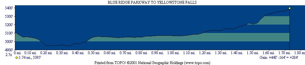
This hike to Yellowstone Falls offers a much easier introduction to the beauty of the Shining Rock Wilderness than the strenuous climbs to the area’s higher peaks. Named for the yellow-colored mosses, lichens, and mineral deposits that coat the rocks surrounding the cascade, Yellowstone Falls is one of the most popular destinations along the Blue Ridge Parkway. The waterfall is located near the well-known Graveyard Fields, a broad mountain valley that was dramatically altered by a devastating wildfire in November 1925. The fire swept across the landscape, destroying much of the dense spruce-fir forest and leaving behind countless charred tree stumps that early visitors thought resembled gravestones scattered across a cemetery. Although the area has largely regenerated, evidence of the fire’s impact can still be seen among the younger forests and open meadows. The hike begins at Blue Ridge Parkway milepost 418.8, where a paved walkway descends to the Yellowstone Prong of the East Fork of the Pigeon River. From there, the Yellowstone Falls Trail—also known as the Graveyard Fields Trail—follows the river through rhododendron thickets and hardwood forest before reaching the picturesque Upper Yellowstone Falls, where the river plunges over a rocky ledge into a clear mountain pool below.
- click for trail photos from this hike to Yellowstone Falls: May 22, 2004
- click for a detailed trip report of this hike in the Shining Rock Wilderness: May 22, 2004 (password required)
- click for a trip report of this hike near Brevard, North Carolina: May 22, 2004 (password required)
- click for the Pisgah Ranger District Trails Illustrated map which details on this area
- click for a topographical and profile map of this hike in the Pisgah National Forest
- click for a map of intersecting trails at Shining Rock (password required)
- click for a photo of intersecting trails at Shining Rock (password required)
- click for another hiking trip to Yellowstone Falls in August 1995
- click for more backpacking trips in the Shining Rock Wilderness in October 1996 and October 1999
- click for the guidebook North Carolina Hiking Trails which has details on this destination