Angel Falls
Chattahoochee-Oconee National Forests
1755 Cleveland Highway
Gainesville, GA 30501
770 297-3000

The Chattahoochee National Forest was established in 1911, when the U.S. Forest Service purchased approximately 31,000 acres of land in Fannin, Gilmer, Lumpkin, and Union Counties from the Gennett family for $7 per acre. Initially, this land was administered as part of the Nantahala and Cherokee National Forests, which extended into North Carolina and Tennessee. Over the years, the Forest Service acquired additional acreage, expanding the protected forestland across the mountains of northern Georgia. Today, the Chattahoochee National Forest encompasses nearly 750,000 acres and provides a wide range of recreational opportunities, including hiking, camping, fishing, and wildlife observation. Within the forest lies the approximately 30,000-acre Cooper Creek Wildlife Management Area in northeastern Georgia. This expansive natural area protects a diverse landscape of mountain ridges, hardwood forests, streams, and wildlife habitat. With nearly 80 miles of trails throughout the management area, visitors can explore the region’s scenic backcountry and enjoy the quiet beauty of the North Georgia mountains.
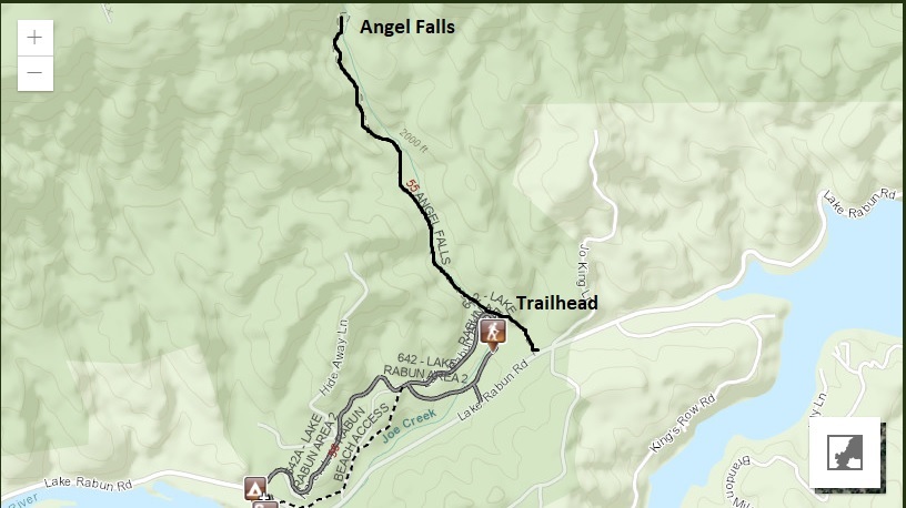
This short, 0.8-mile hike to Angel Falls begins near the back of Rabun Beach Campground and follows Joe Creek through a peaceful, forested setting. The trail climbs gradually alongside the creek, with the sound of flowing water accompanying hikers along much of the route. One of the first points of interest is an old stone spring box that dates to the Civilian Conservation Corps (CCC) era. The spring was used to keep perishable food cool when the CCC operated the campground as a base camp for its conservation and construction projects during the 1930s. The spring still flows today and provides a glimpse into the area’s recreational history. Just beyond it, the trail reaches Panther Falls, the first waterfall along the route. Panther Falls features a pleasant pool at its base, making it a scenic place to pause and enjoy the rushing water. A wooden bench built into the hillside offers a convenient resting spot before continuing farther upstream. Beyond Panther Falls, the trail becomes more challenging, with several short but steep climbs leading to Angel Falls. The larger namesake waterfall is partially screened by surrounding vegetation and does not have the broad pool found below Panther Falls, but its woodland setting and cascading water make it a worthwhile destination. A small viewing platform near Angel Falls provides a place to rest and take in the scenery before retracing the trail to the campground. Although brief, this hike combines two waterfalls, a historic spring, and a scenic creekside walk into an enjoyable outing in the North Georgia mountains.
- click for a video from the base of Angel Falls on Joe Creek: June 20, 2015
- click for more photos from this hike to Angel Falls: June 20, 2015
- click for a trip report for this area near Rabun Beach Campground: June 20, 2015 (password required)
- click for a topographical and profile map from this hike to Angel Falls (password required)
- click for a topo and trail map of this hike to Panther & Angel Falls (password required)
- click for more recreational opportunities in Rabun County, Georgia
- click for the guidebook Best Hikes With Dogs Georgia And South Carolina which details on this area
- click for other Georgia hiking and backpacking books
- click for other hikes in the Blood Mountain Wilderness