Chilkoot Trail (Dyea to Chilkoot Pass)
Klondike Gold Rush National Park
National Forest Service/Parks Canada
P.O. Box 517
Skagway, AK 99840
(907) 983-2921

Klondike Gold Rush National Historical Park commemorates one of the most dramatic and chaotic migration events in North American history. In 1897, news of a major gold discovery in Canada’s Yukon Territory spread rapidly throughout the United States and triggered a massive rush northward as tens of thousands of prospectors — known as stampeders — attempted to reach the Klondike Gold Fields in search of fortune. The coastal town of Skagway quickly became one of the primary gateways to the gold fields and transformed almost overnight into a booming frontier settlement crowded with outfitters, supply stores, saloons, hotels, and hopeful miners. Today, the national historical park preserves this remarkable era through fifteen restored buildings within the Skagway Historic District, where visitors can walk historic boardwalks and explore structures dating back to the height of the gold rush. The park also protects and manages the legendary Chilkoot Trail as well as portions of the White Pass Trail, both of which served as major overland routes into the Yukon. Included within the park is part of the abandoned townsite of Dyea, once a bustling supply camp at the foot of the Chilkoot Trail that later disappeared back into the forest after the gold rush faded. Together, these preserved sites provide a vivid glimpse into the hardships, ambition, and determination that defined the Klondike era.
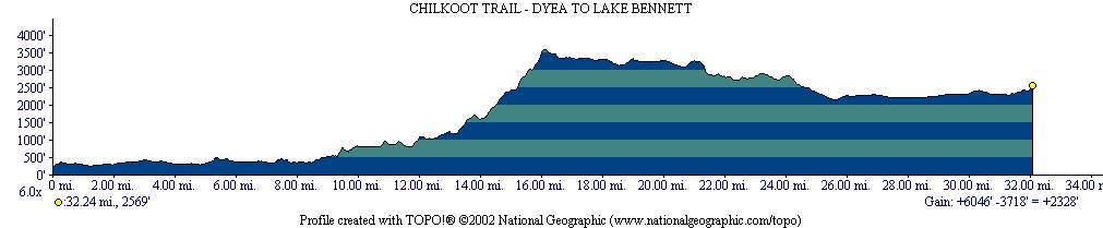
The Chilkoot Trail is often described as a walk back in time because it closely follows the exact route used by stampeders more than a century ago as they struggled toward the Yukon interior. During the gold rush, Canadian authorities required prospectors to carry nearly a year’s worth of supplies before entering Canada, forcing many travelers to haul enormous loads over the mountains in repeated trips. Remnants of that effort can still be found scattered along the trail today, including rusted cans, broken tools, abandoned boilers, and other artifacts slowly being reclaimed by the wilderness. The trail itself is remarkably diverse, beginning in coastal rainforest near Dyea before climbing through muddy valleys, rocky alpine terrain, and snowy mountain passes. Along the route, hikers encounter lush canyons, windswept tundra, glacial lakes, and steep slopes that once formed the infamous “Golden Stairs” leading to Chilkoot Pass. The 33-plus mile journey carries backpackers from Alaska into Canada’s Yukon Territory before descending into British Columbia toward Lake Bennett, where stampeders historically built boats for the next stage of their trip to the Klondike. Many modern hikers complete the experience with a ride aboard the historic White Pass and Yukon Route railway back to Skagway, a spectacular narrow-gauge train route famous for its dramatic mountain scenery, waterfalls, and sheer cliffs. While the Chilkoot is a popular trail with many thru-hikers during the short summer season, it offers an unforgettable combination of wilderness adventure, rich history,
- click for a video from this backpacking trip in Klondike National Park: June 29, 2001
- click for a podcast from our hike on The Chilkoot Trail near Dyea, Alaska
- click for more photos from this backpacking trip on the Chilkoot Trail: June 29, 2001
- click for a detailed trip report of this hike near Skagway, Alaska: June 29, 2001 (password required)
- click for a trip report of this hike from Dyea to Lake Bennett on the Chilkoot Trail: June 29, 2001 (password required)
- click for a Trails Illustrated map of the Chilkoot Trail and the Klondike Gold Rush National Park
- click for a map of the town of Skagway, Alaska where you can pick up your permit for the Chilkoot Trail
- click for a black and white trail map and a black and whilte profile map of the Chilkoot Trail
- click for a topographical and profile map of our backpacking trip on the Chilkoot Trail (password required)
- click for a color profile map of this hike from Dyea to Bennett Lake
- click for a topo map of day one of our hike from Dyea, Alaska to Canyon City on the Chilkoot Trail
- click for a topo map of day two of our hike from Canyon City to Sheep Camp
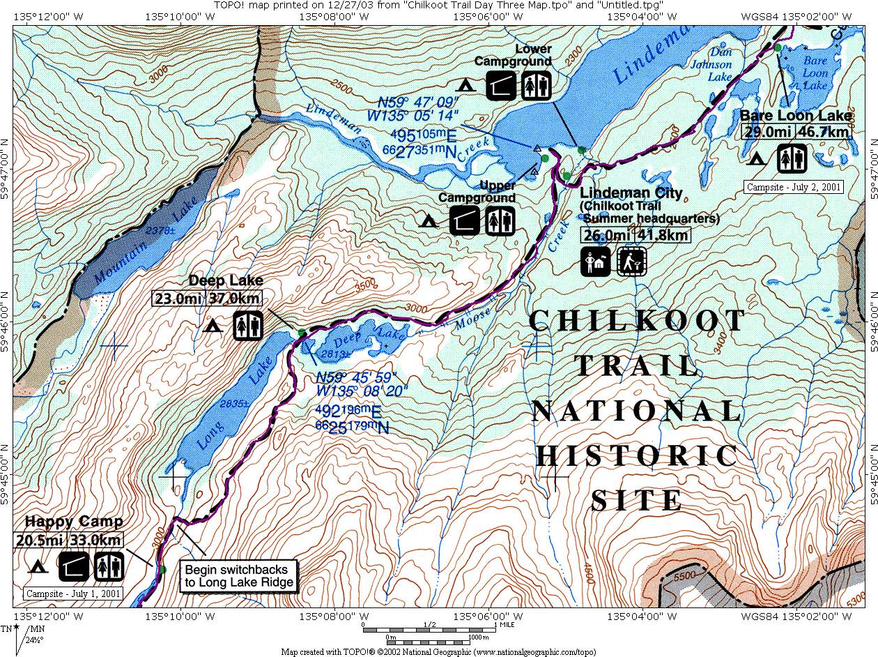
- click for a topo map of day three of our hike from Sheep Camp to the Chilkoot Pass & Happy Camp
- click for a topo map of day four of our hike from the Chilkoot Pass & Happy Camp to Bare Loon Lake
- click for a topo map of day five of our hike from Bare Loon Lake to Lake Bennett
- click for another hike we did to Glacier Bay National Park on this trip
- click for the guidebook Lonely Planet: Backpacking In Alaska which has details on this area
- click for Alaska hiking and backpacking books
- click for Chilkoot Trail hiking and backpacking books


I wonder if the Klondike Gold Rush National Park has a ranger who has an opinion as to whether Klondike Mike carried a piano on his back up the Chilkoot Pass in 1898? This is one of the most famous stories told about the Chilcoot Pass. I am preparing a presentation to the Irish Literary and Historical Society in San Francisco re: Michael Ambrose Mahoney (aka Klondike Mike) He was my father’s first cousin. I would be interested in your opinion, and whether there was any contemporary evidence for this event.