Foothills Trail (SC 107 to Oconee State Park)
Foothills Trail Conference
P.O. Box 3041
Greenville, SC 29602
864.467.9537
Oconee State Park is a 1,165-acre park located near Mountain Rest, SC with activities that include hiking, camping, fishing and boating. The park is bordered by Sumter National Forest and is the trailhead for the 85-mile Foothills Trail. The trail crosses some of the most rugged and beautiful terrain in the Southeast and provides access to major mountain streams and breathtaking views including Sassafrass Mountain, the highest peak in South Carolina. This hike is on the final two sections of this well maintained footpath (which is listed as sections A12 through A14 in the Foothills Trail Guide) and finishes at the western terminus of the route which is located within the Oconee State Park boundary.
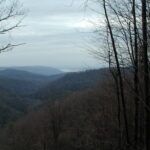
The one-way, shuttle hike over Long Mountain begins at a small parking area just off SC 107 on U.S. Forest Road 710. The route includes a side trip to Hidden Falls which adds two miles to the route. (Hikers also have the option of skipping the side hike and cutting the mileage down to 6.0 miles). To start the route, park a car at both ends of the trail, then ascend briefly from SC 107 for about 0.5 miles around the eastern side of Dodge Mountain. There are some decent views in this area looking down at the valley to the east.
- click for an overview map of the Foothills Trail (password required)
- click to buy the official Foothills Trail map from the Foothills Trail Conference
- click for a topographical & profile map of the entire Foothills Trail (password required)
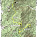
- click for a topo and profile map of this section from SC 107 to Oconee State Park: (password required)
- click to buy a guidebook on the Foothill Trail
- click to access the guidebook Best Hikes With Dogs Georgia And South Carolina which has details on this destination
- click for more information on the Foothills Trail
- click for Foothills Trail hiking and backpacking books
- click for South Carolina hiking and backpacking books
- click for other hikes on the Foothills Trail in South Carolina


