Continental Divide
Savanna Portage State Park
55626 Lake Place
McGregor, MN 55760
(218) 419-1500
Savanna Portage State Park encompasses nearly 16,000 acres of rolling hills, hardwood forests, and glacial lakes. It was established in 1961 and the park preserves the historic Savanna Portage—a challenging 6-mile portage trail once used by Native Americans and early European explorers to connect the Mississippi River to Lake Superior. Savannah Portage was a vital land link between the St. Louis River and the Mississippi River watersheds and it was used for centuries by the native Americans before the white man arrived in mass in the 1760’s to trade furs. The portage joined the heavily traveled canoe route from Lake Superior to the Upper Mississippi via a savannah, which means open grassland with an expanse of marsh grass. The portage was eventually displaced by the railroad and was no longer a vital transportation system in this area.
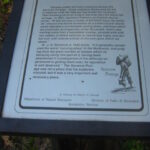
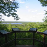
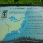
Savannah Portage State Park is named for this six mile portage and it has a system of trails and backcountry campsites within its boundaries. The park offers over 27 miles of hiking trails, including the historic Savanna Portage Trail and the Continental Divide Trail, where waters flow either to the Mississippi River or Lake Superior. The park also has 61 campsites and one camper cabin available year-round. The cabin is accessible and sleeps five, though it lacks running water and electricity. This hike follows the Continental Divide in the park and the trail has outstanding views of Wolf Lake from a platform on the ridge. It is along this route that the continental divide separates the drainages of the Gulf of Mexico and the Atlantic Ocean, and this information is well documented on the hike.
- click for more photos from this hike at Savannah Portage State Park: June 4, 2004
- click for a detailed trip report of this walk along Continental Divide Trail: June 4, 2004 (password required)
- click for a trip report of this hike on the Eastern Continental Divide (password required)
- click for a park map of Savannah Portage State Park
- click for a campground and lake map of for this park
- click for a trail map of Savannah Portage State Park
- click for a topo and profile map of this hike on the Continental Divide Trail (password required)
- click for a topo and profile map for hiking the Savannah Portage Route (password required)
- click for hikes on the Savannah Portage, to Lake Shumway, and on the Continental Divide Trail
- click to access the guidebook Minnesota Hiking which has details on this destination
- click for other Minnesota hiking and backpacking books
- click for more hikes in the State of Minnesota


